make preferable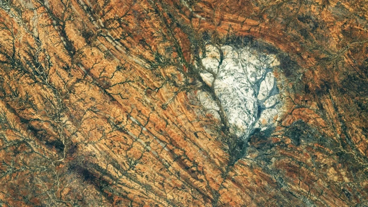
An astronaut aboard the International Space Station photographed an unusual light-colored rocky massif in southern Madagascar, composed of anorthosite — a rock that is widespread in the Moon’s bright highlands. This formation has existed for at least 600 million years and preserves traces of ancient tectonic processes associated with the formation of the supercontinent Gondwana.
NASA published an image of the Saririaky massif through Earth Observatory. The photograph was taken on August 28, 2026, from aboard the ISS. In it, the light-colored rock stands out sharply against the surrounding arid landscape.
A rock found both on Earth and on the Moon
Anorthosite is an igneous rock composed predominantly of plagioclase, a light-colored mineral. It forms when molten rock cools and solidifies beneath Earth’s surface. Under such conditions, minerals can form relatively large crystals.
On Earth, major anorthosite deposits are found in Canada, Scandinavia, southern India, and Madagascar. The Saririaky massif covers about 100 square kilometers and dates to the late Precambrian — a period that began long before the first complex animals appeared.
Especially intriguing is the similarity between this rock and the lunar highlands. Anorthosite makes up a significant part of their bright surface, clearly visible from Earth.
However, this resemblance does not mean that the rocks of Madagascar are of extraterrestrial origin. Anorthosite forms as a result of geological processes that occurred on both Earth and the Moon, although the conditions and history of those processes differed.
Traces of a collision between ancient continents
The Saririaky massif lies within a zone of intense deformation of Earth’s crust, which geologists call a ductile shear zone. At high temperatures and pressures, rocks can gradually bend, stretch, and change structure without breaking instantly, as they would in an ordinary brittle fracture.
Elongated geological structures have been identified in the surrounding rocks, oriented mainly from north to south. They indicate powerful deformations experienced by the region hundreds of millions of years ago.
Scientists link a significant part of these changes to the formation of Gondwana — an ancient supercontinent that included what are now parts of Africa, India, Madagascar, Australia, and Antarctica. As separate landmasses moved closer together and collided, immense pressures and high temperatures reshaped Earth’s crust.
About 60 kilometers north of Saririaky lies another anorthosite massif. Some researchers suggest that the two formations originally constituted a single body of rock, which was later stretched and split under the influence of tectonic forces.
This kind of process is called boudinage: a relatively strong rock layer is stretched and breaks into separate segments because the surrounding materials deform differently. If this hypothesis is correct, the two massifs may preserve evidence of the colossal forces that acted during the formation of the ancient supercontinent.
What Earth’s rocks can tell us about the Moon
Anorthosite is important not only for studying Earth’s history. It also helps scientists reconstruct the early stages of the Moon’s formation.
The Moon’s anorthosite highlands are more than four billion years old. According to a widely accepted scientific model, early in its history the Moon was covered by a global ocean of molten rock. As it cooled, some minerals crystallized and accumulated in the upper layers, forming the primordial lunar crust. Anorthosite became one of its main components.
Samples of lunar rocks brought back to Earth by Apollo astronauts made it possible to study this process directly. However, such samples are relatively few, so Earth deposits of similar rocks are of additional interest to geologists.
One well-known example is found in the Beartooth Mountains in the U.S. state of Montana: the composition of the local anorthosite is close to that of some lunar rocks. By studying such formations, scientists can better understand the conditions under which minerals crystallized and interpret data on the Moon’s geological history.
The Saririaky massif is not part of the Moon and does not in itself prove that the histories of the two celestial bodies developed in the same way. But it clearly shows how similar rock types can arise on different worlds and how Earth’s geological formations help researchers study processes that took place billions of years ago beyond our planet.
About the image: NASA photograph ISS075-E-85249 was taken by a member of Expedition 75 aboard the ISS using a Nikon Z9 digital camera with a 400 mm focal length lens. The image was cropped and contrast-adjusted; optical artifacts were also removed.