make preferable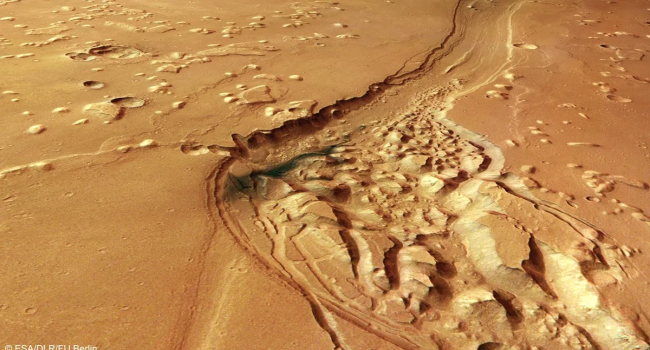
The European spacecraft Mars Express has sent back striking new images of the Shalbatana Vallis region, one of the most compelling pieces of evidence that Mars was once significantly warmer and wetter than it is today.
The images, released by the European Space Agency on May 13, show a heavily eroded and chaotic landscape shaped by catastrophic floods more than 3.5 billion years ago.
What the new images show
Shalbatana Vallis is a vast canyon system located near the Martian equator, stretching for about 1,300 km — roughly the length of Italy. Its main channel reaches up to 10 km in width and about 500 meters in depth.
Scientists are particularly interested in the so-called chaotic terrain — regions where rock formations appear broken into displaced blocks. Planetary geologists believe this landscape formed when underground ice suddenly melted, causing the surface to collapse.
Next to these chaotic zones are winding valleys that were carved by powerful water flows, likely released suddenly from beneath the surface.
A complex geological history
The images reveal multiple layers of Mars’s geological history. Over time, the canyon was gradually filled with sediments, volcanic ash, and other materials, making it appear shallower today than it originally was.
Dark blue-black deposits are likely volcanic ash redistributed by Martian winds. Craters, folded ridges, and isolated mesa-like formations record billions of years of alternating catastrophic flooding events, lava flows, and erosion.
Why this region matters
Shalbatana Vallis flows into Chryse Planitia, one of the lowest-lying regions on Mars. Some scientists suggest that this area may once have hosted a vast ancient ocean.
Such regions are especially valuable for research because they preserve direct evidence of Mars’s warm and wet past.
About the Mars Express mission
Launched in 2003, Mars Express remains one of the longest-operating spacecraft orbiting Mars. Its high-resolution HRSC camera has spent more than 20 years producing detailed color and 3D maps of the planet. Over its mission, it has significantly expanded knowledge of Mars’s watery past, identified water-formed minerals, studied subsurface ice deposits, and contributed to debates about possible liquid water beneath the southern polar cap.
In brief
Mars Express has captured new high-resolution images of Shalbatana Vallis, a 1,300 km canyon system formed by massive floods around 3.5 billion years ago. The images reveal chaotic terrain created by sudden melting of underground ice, along with evidence of powerful water flows, volcanic activity, and long-term erosion. The region is of high scientific interest because it preserves traces of Mars’s warm and wet ancient environment.