US scientists create a detailed 3D map of Mars available to anyone
Viewing the Martian landscape has become more accessible than ever before, thanks to a groundbreaking map created from a wealth of data collected by NASA's Mars Reconnaissance Orbiter. This new map, generated with the assistance of supercomputers and cloud computing, offers a high-resolution, three-dimensional experience of Mars' otherworldly terrain, Space.com reports.
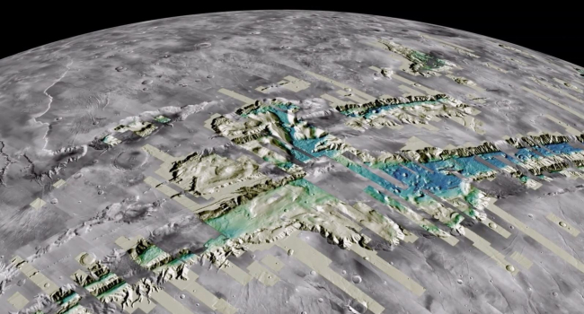
A team at the U.S. Geological Survey's Astrogeology Science Center (ASC) processed the map, which comprises over 4,800 digital terrain models (DTMs) and an astonishing 155,000 images of the Martian surface. Team leader Jay Laura expressed his excitement, stating, "Now anyone on the planet with a smartphone can search, use and marvel at these data." He emphasized the importance of democratizing access to high-quality Mars topographic data, allowing more people to contribute to scientific discovery.
The team utilized topographic data collected by the Mars Reconnaissance Orbiter's Context Camera, which captures images at a resolution of approximately 6 meters per pixel, covering an area up to 18.5 miles wide and 100 miles long. By overlapping and processing two images of the same area with a supercomputer, the team produced detailed 3D views. This process mirrors how our brain processes visual data from our eyes, enabling depth perception and a 3D representation of our surroundings.
Aligning image pairs to the topography of Mars was a challenging task. The team had to align individual DTMs to global low-resolution topography, a process that required immense computing power and several weeks to complete. To put it into perspective, processing the data on a standard personal computer would take between two and 35 years of continuous processing. The team managed to complete this step by utilizing the Denali supercomputer located at the Eros Data Center in Sioux Falls, South Dakota.
The 4,800 DTMs are just a fraction of the available Mars data. The ASC team is currently working on thousands of other image pairs to improve the topographic coverage of Mars at a resolution of 20 meters per pixel. Moreover, the team collected higher-resolution image pairs with the High-Resolution Imaging Science Experiment (HiRISE) camera, covering smaller patches of Mars' surface, approximately 3.7 miles wide and 37 miles long. These HiRISE images provide incredible detail at a resolution of 25 cm per pixel but have a substantial data size, averaging over 1 GB.
To facilitate the handling of such detailed photos, the ASC team processed the entire catalog of 155,000 HiRISE images, totaling approximately 114 TB of data. They made the data streamable and freely accessible, eliminating the need to download whole images. The processing took advantage of the NASA Planetary Data System cloud holdings, enabling the simultaneous processing of over 4,000 images and completing the entire dataset in under four hours.
This streamable data can be examined on smartphones or downloaded in a ready-to-use format, bypassing the need for further processing. These fully processed images are deemed vital by the NASA Planetary Data Ecosystem Independent Review Board for supporting the application of AI and machine learning to planetary science. Laura emphasized the potential of these data for machine-learning scientists, stating, "These data are ripe for discovery and use by machines and humans."
The data is hosted by Amazon in their Open Data Registry and is available for anyone to use. To enhance accessibility, the USGS has released search tools, making it easier for the general public to locate and download the data. Laura concluded by highlighting the USGS's commitment to developing and releasing analysis-ready planetary science data with releases like this.
- Related News
- Perseverance finds rock on Mars with signs of life on Earth (photo)
- On 25th anniversary of Chandra telescope, NASA released 25 photos previously unseen by the public
- Rare intermediate-mass black hole has been discovered at the center of our galaxy
- Stone "snowman" and pure sulfur crystals on Mars։ Remarkable discoveries by Perseverance and Curiosity
- When will humanity settle on Mars? Interview with Gernot Grömer
- TESS telescope discovers super-hot exoplanet the size of Neptune
- Most read
month
week
day
- Buyers massively complain about Samsung's Galaxy Buds 3 and Buds 3 Pro headphone, even finding hair in the box 824
- With today's mortgage interest rates, banks simply cannot sell products in 2025: Interview with Vardan Marutyan 816
- Ants and bees 'taught' tiny drones to navigate without GPS, beacons or lidars 677
- Samsung will release Galaxy Tab S10+ and Ultra tablets and Galaxy Z Fold 6 Slim and Galaxy w25 smartphones in October 645
- Mass production of iPhone SE 4 will begin this October, with sales starting in 2025 607
- Insider unveils specs of all smartphones of iPhone 17 series, including the 17 Slim 606
- Telegram's monthly active audience reaches 950 million 587
- What are the problems in the construction industry? Interview with Vardan Marutyan 566
- For the first time in history, iPhone will get a Samsung camera 564
- What dangers can feature phones from unknown manufacturers conceal? 560
- Archive