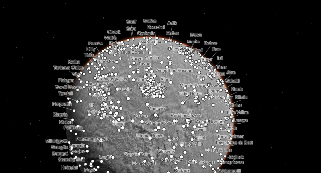
An interactive map of Mars has been created։ Anyone can spot rocks and traces of storms on it
A new interactive map of Mars has been released online, where anyone can find rocks, impact craters and storm tracks in amazing detail.
The map was created from 110,000 images taken by the black-and-white Context Camera (CTX) on NASA's Mars Reconnaissance Orbiter (MRO).
This is the most detailed map ever created with the highest resolution (25 square meters per pixel). It was created by the scientists of the Bruce Murray Planetary Visualization Laboratory of the California Institute of Technology over the course of six years.
To create the map, the team developed an algorithm that automatically combined the photos based on the details of the surface depicted in them. However, 13,000 photos that the algorithm could not process, experts had to manually attach to the map.
The map is so detailed that it has already been cited in more than 120 peer-reviewed scientific articles. At the same time, the map is simple enough that anyone can understand how to use it.
Beneath the new map are buttons that allow you to quickly find popular locations such as Gale Crater and Jezero Crater, which are being explored by NASA's Curiosity and Perseverance rovers. One can also manually rotate the 3D image of the planet and view points of interest.
However, there are gaps in the map: these are the parts of the planet that were not captured by CTX when work on this project had already begun. Areas covered by clouds or dust are also not visible on the map.
- Related News
- Perseverance finds rock on Mars with signs of life on Earth (photo)
- On 25th anniversary of Chandra telescope, NASA released 25 photos previously unseen by the public
- Rare intermediate-mass black hole has been discovered at the center of our galaxy
- Stone "snowman" and pure sulfur crystals on Mars։ Remarkable discoveries by Perseverance and Curiosity
- When will humanity settle on Mars? Interview with Gernot Grömer
- TESS telescope discovers super-hot exoplanet the size of Neptune
- Most read
month
week
day
- Buyers massively complain about Samsung's Galaxy Buds 3 and Buds 3 Pro headphone, even finding hair in the box 821
- With today's mortgage interest rates, banks simply cannot sell products in 2025: Interview with Vardan Marutyan 812
- Ants and bees 'taught' tiny drones to navigate without GPS, beacons or lidars 676
- Samsung will release Galaxy Tab S10+ and Ultra tablets and Galaxy Z Fold 6 Slim and Galaxy w25 smartphones in October 641
- Mass production of iPhone SE 4 will begin this October, with sales starting in 2025 602
- Insider unveils specs of all smartphones of iPhone 17 series, including the 17 Slim 599
- Telegram's monthly active audience reaches 950 million 585
- What dangers can feature phones from unknown manufacturers conceal? 558
- For the first time in history, iPhone will get a Samsung camera 555
- What are the problems in the construction industry? Interview with Vardan Marutyan 550
- Archive
