NASA publishes map of areas containing water ice on Mars: Why is it important?
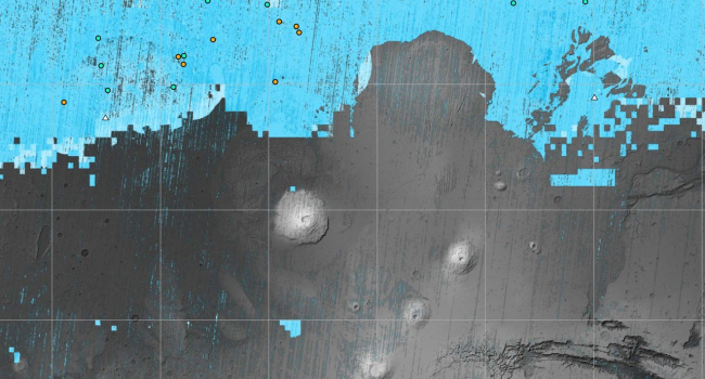
NASA specialists have published an updated map of Mars, pinpointing potential water ice deposits beneath the planet's surface. The map highlights regions where water ice is believed to exist at depths not exceeding one meter. Water ice is a crucial resource that could fuel and sustain future missions to Mars, whether manned or robotic. The presence of easily accessible ice will be a determining factor in selecting landing sites for future expeditions.
For NASA's missions to Mars, water is needed in regions of moderate latitudes, specifically those near the equator. While water ice is almost certainly present at the poles and in polar regions, the extremely low temperatures there prevent it from evaporating into the planet's thin atmosphere. However, residing at the poles or within the Martian Arctic Circle is resource-intensive.
The equatorial zone, although the warmest, is less suitable for gentle landings due to the challenging atmospheric conditions. The Martian atmosphere is already extremely thin, making it difficult to slow descent vehicles. Therefore, regions with moderate latitudes that are closer to the equator are considered ideal for landing and establishing bases. This is where NASA's Subsurface Water Ice Mapping program focuses its search for subsurface water ice.
The updated map, displaying probable water ice locations at depths of up to one meter, is based on data from three Martian orbital spacecraft: the Mars Reconnaissance Orbiter (MRO), the Mars Odyssey from 2001, and the now-inactive Mars Global Surveyor. Previous data was made public in 2017. Scientists analyze Mars' surface images and identify potential water ice locations based on specific surface features, such as seasonal fissures or certain soil types that develop in the presence of water.
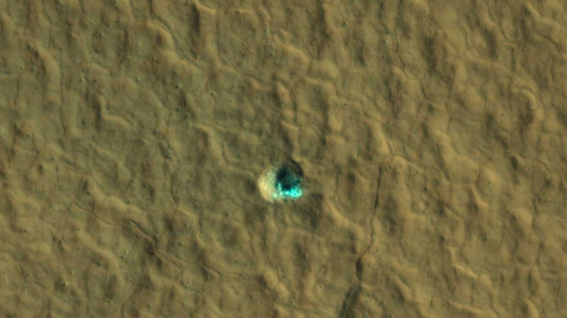
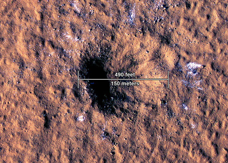
Particularly valuable for detecting water ice on Mars are fresh impact craters caused by meteorite strikes. These craters, often around 10 meters in diameter, displace soil and reveal ice. In some cases, researchers even benefit from the fortuitous discovery of craters as large as 150 meters in diameter created by particularly massive meteorite impacts. In such fractures, high-resolution orbital cameras clearly capture ice traces. Scientists use indirect data to identify signs of subsurface ice, and meteorites effectively corroborate these findings.
NASA's future plans include a specialized radar scan program to investigate subsurface ice on Mars. To achieve this, the Mars Ice Mapper spacecraft with a powerful specialized radar will be sent into Mars orbit. This will expand the mapping of potential water ice distribution areas on Mars and likely confirm today's observations.
- Related News
- Wheel of Death: new method will help astronauts stay fit in low gravity
- Due to anomalies of Orion spacecraft, lunar exploration program may be delayed for years։ NASA
- TAO Observatory: World's highest telescope to study evolution of galaxies and exoplanets
- Powerful M9.5 solar flare causes radio blackout in Pacific Ocean
- What will happen to the Earth if the Moon disappears?
- Key to conquering the Red Planet: Why is NASA studying solar storms on Mars?
- Most read
month
week
day
- Digital Julfa Network is launching a pan-Armenian centre in the metaverse, on the Fastexverse virtual platform 996
- Xiaomi unveils exclusive Redmi Note 13 Pro+ dedicated to Messi and Argentina national team 875
- Sparkles: Boston Dynamics unveils a furry robot dog that can dance (video) 834
- Is there a ninth planet in the solar system? Scientists find new evidence 702
- What will happen to the Earth if the Moon disappears? 693
- Internet 500 times faster than 5G tested in Japan: It allows to transfer five movies in HD resolution in one second 685
- Smartphone catches fire in child's hand in Russia 677
- iPhone 16 may get colored matte glass back panel, 7 colors 672
- How to understand how protected a smartphone is from water and dust? 670
- World's largest 3D printer was created in USL It prints 29 meter-long structures 656
- Archive